


refuge periere/St pierre d allevard

Tof Tof
User
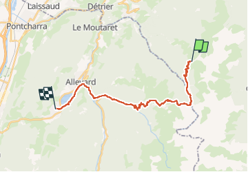

Length
23 km

Max alt
1962 m

Uphill gradient
918 m
Km-Effort
40 km

Min alt
472 m

Downhill gradient
2239 m
Boucle
No
Creation date :
2022-05-14 07:22:36.021
Updated on :
2022-05-14 15:12:34.382
7h48
Difficulty : Difficult

FREE GPS app for hiking
 SityTrail
IGN / Geographical institutes
SityTrail Plus
The world is yours!
About
Trail Walking of 23 km to be discovered at Auvergne-Rhône-Alpes, Savoy, Arvillard. This trail is proposed by Tof Tof.
Positioning
Country:
France
Region :
Auvergne-Rhône-Alpes
Department/Province :
Savoy
Municipality :
Arvillard
Location:
Unknown
Start:(Dec)
Start:(UTM)
279740 ; 5032090 (32T) N.
Comments