


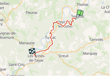
de Thonac à Les Eyzies

phimar_2612
User

Length
20 km

Max alt
236 m

Uphill gradient
553 m
Km-Effort
28 km

Min alt
61 m

Downhill gradient
598 m
Boucle
No
Creation date :
2022-05-17 08:13:55.856
Updated on :
2022-05-17 15:59:05.873
5h02
Difficulty : Very difficult

FREE GPS app for hiking
 SityTrail
IGN / Geographical institutes
SityTrail Plus
The world is yours!
About
Trail Walking of 20 km to be discovered at New Aquitaine, Dordogne, Sergeac. This trail is proposed by phimar_2612.
Positioning
Country:
France
Region :
New Aquitaine
Department/Province :
Dordogne
Municipality :
Sergeac
Location:
Unknown
Start:(Dec)
Start:(UTM)
350394 ; 4984408 (31T) N.
Comments