


2022 GR 10 étape 2 Olhette/Ainhoa

chasle
User
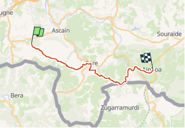

Length
20 km

Max alt
562 m

Uphill gradient
732 m
Km-Effort
30 km

Min alt
47 m

Downhill gradient
710 m
Boucle
No
Creation date :
2022-05-19 06:04:29.893
Updated on :
2022-05-19 06:05:47.505
6h45
Difficulty : Difficult

FREE GPS app for hiking
 SityTrail
IGN / Geographical institutes
SityTrail Plus
The world is yours!
About
Trail Walking of 20 km to be discovered at New Aquitaine, Pyrénées-Atlantiques, Urrugne. This trail is proposed by chasle.
Positioning
Country:
France
Region :
New Aquitaine
Department/Province :
Pyrénées-Atlantiques
Municipality :
Urrugne
Location:
Unknown
Start:(Dec)
Start:(UTM)
608642 ; 4798564 (30T) N.
Comments