Trail Walking Peyreleau - Ermitage St Michel 19-05-22 - Photo

Ermitage St Michel 19-05-22

© OpenStreetMap contributors
Length
Length
10.3 km
Max alt
Max alt
842 m
Uphill gradient
Uphill gradient
581 m
Km-Effort
Km-Effort  
18 km
Min alt
Min alt
401 m
Downhill gradient
Downhill gradient
578 m
Boucle
Boucle
Yes
Creation date :
2022-05-19 07:08:25.747
Updated on :
2022-05-21 15:54:26.014

(0 Reviews)

Walking
Walking
2h50
Difficulty : Medium

Scan this QR Code to open this trail in the SityTrail application

FREE GPS app for hiking

Logo SityTrail SityTrail

IGN / Geographical institutes

Download SityTrail from the App Store Download SityTrail from Google Play

Logo SityTrail SityTrail World

The world is yours!

Download SityTrail from the App Store Download SityTrail from Google Play Download SityTrail on Huawei AppGallery

About

Trail Walking of 10.3 km to be discovered at Occitania, Aveyron, Peyreleau. This trail is proposed by Christiancordin.

Description

Peyreleau (PK de la mairie)-corniche du causse noir-champignon préhistorique-point sublime-ermitage St Michel-la Jonte.

Elevation profile

Photos

Positioning

Country:
France
Region :
Occitania
Department/Province :
Aveyron
Municipality :
Peyreleau
Location:
Unknown
Start:(UTM)
516684 ; 4892792 (31T) N.

Trails nearby

Trail Walking Mostuéjouls - Cirque de Saint Marcellin - Mostuéjouls - Liaucous - Photo
Walking
tracegps

Walking

Medium
(1)
Mostuéjouls, Occitania, Aveyron, France
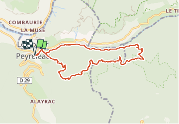
15.4 km | 24 km-effort
5h 0min
Yes
Trail Walking Le Rozier - Causse et gorges au pays des vautours  - Photo
Walking
GUIDE
nadinebondoux

Walking

Difficult
Le Rozier, Occitania, Lozère, France
27 km | 40 km-effort
7h 48min
No
Trail Walking Saint-Pierre-des-Tripiers - Cassagnes crête vallée Jonte et Tarn 12,2 km - Photo
Walking
GUIDE
rvapeldo

Walking

Medium
Saint-Pierre-des-Tripiers, Occitania, Lozère, France
12.6 km | 20 km-effort
5h 38min
No
Trail Walking Veyreau - J3 St Jean des Balmes Ermitage St Michel - Photo
Walking
ARPF

Walking

Easy
(2)
Veyreau, Occitania, Aveyron, France
9.6 km | 13.9 km-effort
3h 18min
Yes
Trail Walking Saint-Pierre-des-Tripiers - Les corniches du Méjean - Photo
Walking
ZURMELY

Walking

Medium
(3)
Saint-Pierre-des-Tripiers, Occitania, Lozère, France
6 km | 9.5 km-effort
2h 31min
Yes
Trail Walking Saint-Pierre-des-Tripiers - LL34-Corniches du Méjean - Photo
Walking
alainandrejoly

Walking

Difficult
(1)
Saint-Pierre-des-Tripiers, Occitania, Lozère, France
12.1 km | 25 km-effort
4h 51min
Yes
Trail Walking Saint-Pierre-des-Tripiers - vautour - Photo
Walking
aezret

Walking

Medium
(1)
Saint-Pierre-des-Tripiers, Occitania, Lozère, France
7.1 km | 12.3 km-effort
2h 59min
Yes
Trail Walking Le Rozier - Sur Les Hauteurs De Peyreleau - Photo
Walking
Patakk

Walking

Difficult
(2)
Le Rozier, Occitania, Lozère, France
10.4 km | 18.2 km-effort
4h 0min
Yes
Trail Walking Peyreleau - Le 815 - Peyreleau - Photo
Walking
tracegps

Walking

Easy
(1)
Peyreleau, Occitania, Aveyron, France
5.5 km | 10.5 km-effort
2h 0min
Yes


Close
My subscriptions