


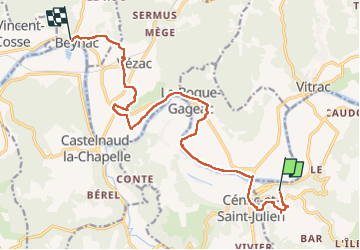
de Domme à Beynac

phimar_2612
User

Length
15.5 km

Max alt
215 m

Uphill gradient
295 m
Km-Effort
19.8 km

Min alt
65 m

Downhill gradient
422 m
Boucle
No
Creation date :
2022-05-20 07:12:59.956
Updated on :
2022-05-20 14:04:56.522
4h17
Difficulty : Difficult

FREE GPS app for hiking
 SityTrail
IGN / Geographical institutes
SityTrail Plus
The world is yours!
About
Trail Walking of 15.5 km to be discovered at New Aquitaine, Dordogne, Domme. This trail is proposed by phimar_2612.
Positioning
Country:
France
Region :
New Aquitaine
Department/Province :
Dordogne
Municipality :
Domme
Location:
Unknown
Start:(Dec)
Start:(UTM)
358766 ; 4962679 (31T) N.
Comments