


GR 10 6

chasle
User
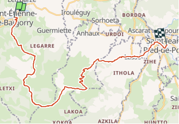

Length
18.9 km

Max alt
1015 m

Uphill gradient
1005 m
Km-Effort
32 km

Min alt
155 m

Downhill gradient
981 m
Boucle
No
Creation date :
2022-05-23 20:33:38.485
Updated on :
2022-05-23 20:34:38.31
7h18
Difficulty : Difficult

FREE GPS app for hiking
 SityTrail
IGN / Geographical institutes
SityTrail Plus
The world is yours!
About
Trail Walking of 18.9 km to be discovered at New Aquitaine, Pyrénées-Atlantiques, Saint-Étienne-de-Baïgorry. This trail is proposed by chasle.
Positioning
Country:
France
Region :
New Aquitaine
Department/Province :
Pyrénées-Atlantiques
Municipality :
Saint-Étienne-de-Baïgorry
Location:
Unknown
Start:(Dec)
Start:(UTM)
634742 ; 4781841 (30T) N.
Comments