


GR 10 11

chasle
User
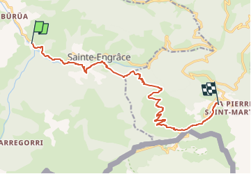

Length
14.7 km

Max alt
1775 m

Uphill gradient
1389 m
Km-Effort
29 km

Min alt
465 m

Downhill gradient
161 m
Boucle
No
Creation date :
2022-05-23 21:32:03.967
Updated on :
2022-05-23 21:32:35.539
6h36
Difficulty : Difficult

FREE GPS app for hiking
 SityTrail
IGN / Geographical institutes
SityTrail Plus
The world is yours!
About
Trail Walking of 14.7 km to be discovered at New Aquitaine, Pyrénées-Atlantiques, Sainte-Engrâce. This trail is proposed by chasle.
Positioning
Country:
France
Region :
New Aquitaine
Department/Province :
Pyrénées-Atlantiques
Municipality :
Sainte-Engrâce
Location:
Unknown
Start:(Dec)
Start:(UTM)
675746 ; 4763127 (30T) N.
Comments