


GR 10 15

chasle
User
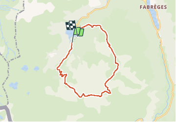

Length
14.8 km

Max alt
2312 m

Uphill gradient
991 m
Km-Effort
28 km

Min alt
1415 m

Downhill gradient
1012 m
Boucle
No
Creation date :
2022-05-23 21:48:25.236
Updated on :
2022-05-23 21:48:54.944
6h23
Difficulty : Difficult

FREE GPS app for hiking
 SityTrail
IGN / Geographical institutes
SityTrail Plus
The world is yours!
About
Trail Walking of 14.8 km to be discovered at New Aquitaine, Pyrénées-Atlantiques, Laruns. This trail is proposed by chasle.
Positioning
Country:
France
Region :
New Aquitaine
Department/Province :
Pyrénées-Atlantiques
Municipality :
Laruns
Location:
Unknown
Start:(Dec)
Start:(UTM)
707981 ; 4748568 (30T) N.
Comments