


geroise 16km fait

LouisROGER
User GUIDE
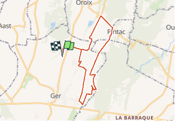

Length
18 km

Max alt
406 m

Uphill gradient
137 m
Km-Effort
19.9 km

Min alt
369 m

Downhill gradient
136 m
Boucle
Yes
Creation date :
2022-05-25 07:03:08.556
Updated on :
2022-05-25 10:50:46.44
3h47
Difficulty : Easy

FREE GPS app for hiking
 SityTrail
IGN / Geographical institutes
SityTrail Plus
The world is yours!
About
Trail Mountain bike of 18 km to be discovered at New Aquitaine, Pyrénées-Atlantiques, Ger. This trail is proposed by LouisROGER.
Positioning
Country:
France
Region :
New Aquitaine
Department/Province :
Pyrénées-Atlantiques
Municipality :
Ger
Location:
Unknown
Start:(Dec)
Start:(UTM)
739575 ; 4795358 (30T) N.
Comments