Trail Walking Saint-Césaire - Saint Bris des Bois - Photo
 reva17
reva17

User

© OpenStreetMap contributors
Length
Length
13.2 km
Max alt
Max alt
85 m
Uphill gradient
Uphill gradient
189 m
Km-Effort
Km-Effort  
15.7 km
Min alt
Min alt
36 m
Downhill gradient
Downhill gradient
190 m
Boucle
Boucle
Yes
Creation date :
2014-12-10 00:00:00.0
Updated on :
2014-12-10 00:00:00.0

(0 Reviews)

Walking
Walking
3h30
Difficulty : Medium

Scan this QR Code to open this trail in the SityTrail application

FREE GPS app for hiking

Logo SityTrail SityTrail

IGN / Geographical institutes

Download SityTrail from the App Store Download SityTrail from Google Play

Logo SityTrail SityTrail World

The world is yours!

Download SityTrail from the App Store Download SityTrail from Google Play Download SityTrail on Huawei AppGallery

About

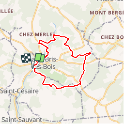
Trail Walking of 13.2 km to be discovered at New Aquitaine, Charente-Maritime, Saint-Césaire. This trail is proposed by reva17.

Description

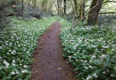
Belle boucle dans la campagne charentaise, passant par 7 sources et lavoirs, avec une vue sympathique de l'abbaye de Fontdouce.

Elevation profile

Photos

Points of interest

Point of interest Saint-Césaire -  Les 7 sources Saint Bris des Bois - Photo
reva17

Positioning

Country:
France
Region :
New Aquitaine
Department/Province :
Charente-Maritime
Municipality :
Saint-Césaire
Location:
Unknown
Start:(UTM)
694705 ; 5070893 (30T) N.

Trails nearby

Trail Equestrian La Chapelle-des-Pots - Circuit des potiers - La Chapelle des Pots - Photo
Equestrian
tracegps

Equestrian

Easy
(1)
La Chapelle-des-Pots, New Aquitaine, Charente-Maritime, France
7.2 km | 8.5 km-effort
1h 19min
Yes
Trail Walking La Chapelle-des-Pots - la Chapelle des Pots ( D ROUSSET) - Photo
Walking
Claudinette17

Walking

Medium
(1)
La Chapelle-des-Pots, New Aquitaine, Charente-Maritime, France
7.8 km | 8.8 km-effort
2h 40min
Yes
Trail Walking La Chapelle-des-Pots - La Chapelle des Pots - Asphodèles - Photo
Walking
Claudinette17

Walking

Easy
(1)
La Chapelle-des-Pots, New Aquitaine, Charente-Maritime, France
7.4 km | 8.7 km-effort
2h 5min
Yes
Trail Mountain bike La Chapelle-des-Pots - Circuit des potiers - La Chapelle des Pots - Photo
Mountain bike
tracegps

Mountain bike

Easy
La Chapelle-des-Pots, New Aquitaine, Charente-Maritime, France
7.2 km | 8.5 km-effort
34min
Yes
Trail Walking La Chapelle-des-Pots - Circuit des potiers - La Chapelle des Pots - Photo
Walking
tracegps

Walking

Medium
La Chapelle-des-Pots, New Aquitaine, Charente-Maritime, France
7.2 km | 8.5 km-effort
2h 0min
Yes
Trail Walking Saint-Césaire - La Vallée du Coran - St Bris des Bois - Photo
Walking
tracegps

Walking

Medium
Saint-Césaire, New Aquitaine, Charente-Maritime, France
7.4 km | 8.9 km-effort
2h 0min
Yes
Trail Walking Vénérand - venerand - Photo
Walking
jpland17800

Walking

Very difficult
Vénérand, New Aquitaine, Charente-Maritime, France
24 km | 28 km-effort
6h 21min
No
Trail Walking La Chapelle-des-Pots - la chapelle des pots - Photo
Walking
niniroro51

Walking

Medium
La Chapelle-des-Pots, New Aquitaine, Charente-Maritime, France
5.9 km | 7.1 km-effort
2h 2min
Yes
Trail Running Villars-les-Bois - Course de côtes - Photo
Running
Arts Terre

Running

Difficult
Villars-les-Bois, New Aquitaine, Charente-Maritime, France
15.1 km | 19.2 km-effort
Unknown
Yes


Close
My subscriptions