Trail Road bike Cognin-les-Gorges - Alpes 2022 / Cognin-les-Gorges / Tour dans le Vercors - Photo

Alpes 2022 / Cognin-les-Gorges / Tour dans le Vercors

 bosses21
bosses21

User

© OpenStreetMap contributors
Length
Length
125 km
Max alt
Max alt
1388 m
Uphill gradient
Uphill gradient
2877 m
Km-Effort
Km-Effort  
164 km
Min alt
Min alt
169 m
Downhill gradient
Downhill gradient
2877 m
Boucle
Boucle
Yes
Creation date :
2022-05-26 16:35:22.738
Updated on :
2022-06-14 10:07:32.8

(0 Reviews)

Road bike
Road bike
9h54
Difficulty : Very difficult

Scan this QR Code to open this trail in the SityTrail application

FREE GPS app for hiking

Logo SityTrail SityTrail

IGN / Geographical institutes

Download SityTrail from the App Store Download SityTrail from Google Play

Logo SityTrail SityTrail World

The world is yours!

Download SityTrail from the App Store Download SityTrail from Google Play Download SityTrail on Huawei AppGallery

About

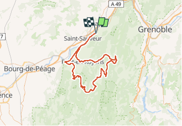
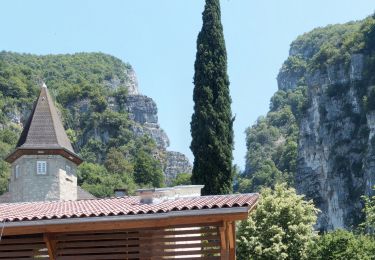
Trail Road bike of 125 km to be discovered at Auvergne-Rhône-Alpes, Isère, Cognin-les-Gorges. This trail is proposed by bosses21.

Description

Col Gaudissart - Col de la Machine - Col de Carri - Col d'Herbouilly - Col de Chalimont

Elevation profile

Points of interest

Point of interest Saint-Jean-en-Royans - Col Gaudissart - Photo
bosses21
SAINT-JEAN-EN-ROYANS 
Point of interest Bouvante - Col de la Machine - Photo
bosses21
Point of interest La Chapelle-en-Vercors - Col de Carri - Photo
bosses21
LA CHAPELLE-EN-VERCORS 
Point of interest Villard-de-Lans - Col d'Herbouilly - Photo
bosses21
VILLARD-DE-LANS 
Point of interest Villard-de-Lans - Col de Chalimont - Photo
bosses21
VILLARD-DE-LANS 

Positioning

Country:
France
Region :
Auvergne-Rhône-Alpes
Department/Province :
Isère
Municipality :
Cognin-les-Gorges
Location:
Unknown
Start:(UTM)
689782 ; 5004817 (31T) N.

Trails nearby

Trail Walking Cognin-les-Gorges - gerlette abs - Photo
Walking
dorane

Walking

Very easy
(1)
Cognin-les-Gorges, Auvergne-Rhône-Alpes, Isère, France
15.8 km | 31 km-effort
7h 12min
Yes
Trail Walking Malleval-en-Vercors - pas du Follet en boucle - Photo
Walking
cmarit

Walking

Medium
(1)
Malleval-en-Vercors, Auvergne-Rhône-Alpes, Isère, France
16.7 km | 26 km-effort
6h 59min
Yes
Trail Mountain bike Vinay - Vinay-Plaine-Pont de Treillins - Photo
Mountain bike
crocau

Mountain bike

Very easy
Vinay, Auvergne-Rhône-Alpes, Isère, France
10 km | 11.7 km-effort
1h 11min
Yes
Trail Walking Malleval-en-Vercors - Patente - Photo
Walking
crocau

Walking

Difficult
Malleval-en-Vercors, Auvergne-Rhône-Alpes, Isère, France
9.9 km | 13.4 km-effort
3h 7min
Yes
Trail Walking Cognin-les-Gorges - Cognin-les-Gorges - Gorges du Nan - Malleval-en-Vercors - Photo
Walking
Philindy26

Walking

Difficult
Cognin-les-Gorges, Auvergne-Rhône-Alpes, Isère, France
15.6 km | 30 km-effort
5h 30min
Yes
Trail Walking Izeron - La lunette- fontaine et grotte de Byry - Photo
Walking
crocau

Walking

Medium
Izeron, Auvergne-Rhône-Alpes, Isère, France
4.8 km | 7.4 km-effort
3h 0min
Yes
Trail Walking Cognin-les-Gorges - Cognin les gorges  - Photo
Walking
Sylvie.P

Walking

Medium
Cognin-les-Gorges, Auvergne-Rhône-Alpes, Isère, France
15.5 km | 30 km-effort
4h 28min
No
Trail Walking Cognin-les-Gorges - Les gorges du Nan - Photo
Walking
crocau

Walking

Medium
Cognin-les-Gorges, Auvergne-Rhône-Alpes, Isère, France
4.8 km | 11.4 km-effort
2h 13min
Yes
Trail Walking Izeron - Monchardon-Gonthier - Photo
Walking
crocau

Walking

Very easy
(1)
Izeron, Auvergne-Rhône-Alpes, Isère, France
6.4 km | 12.1 km-effort
2h 19min
Yes


Close
My subscriptions