Trail Mountain bike Porte-de-Savoie - col du Granier, Gorgeat, Coche - Photo

col du Granier, Gorgeat, Coche

 jmperi
jmperi

User

© OpenStreetMap contributors
Length
Length
37 km
Max alt
Max alt
1477 m
Uphill gradient
Uphill gradient
1474 m
Km-Effort
Km-Effort  
57 km
Min alt
Min alt
285 m
Downhill gradient
Downhill gradient
1473 m
Boucle
Boucle
Yes
Creation date :
2022-05-28 07:32:18.551
Updated on :
2022-05-31 12:39:49.297

(0 Reviews)

Mountain bike
Mountain bike
4h32
Difficulty : Very difficult

Scan this QR Code to open this trail in the SityTrail application

FREE GPS app for hiking

Logo SityTrail SityTrail

IGN / Geographical institutes

Download SityTrail from the App Store Download SityTrail from Google Play

Logo SityTrail SityTrail Plus

The world is yours!

Download SityTrail from the App Store Download SityTrail from Google Play Download SityTrail on Huawei AppGallery

About

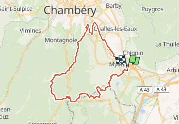
Trail Mountain bike of 37 km to be discovered at Auvergne-Rhône-Alpes, Savoy, Porte-de-Savoie. This trail is proposed by jmperi.

Description

Les Marches, lac noir, sentier des charbonniers, col du Granier, granges de Joigny, Gorgeat, Lentille, Essort, pas de la Fosse, bec du corbeau, Croix de la Coche, la Chambotte, La Villette, allée verte sud, Myans,  Les Marches. 4h avec 20 min de pause.

Elevation profile

Positioning

Country:
France
Region :
Auvergne-Rhône-Alpes
Department/Province :
Savoy
Municipality :
Porte-de-Savoie
Location:
Les Marches
Start:(UTM)
734341 ; 5043620 (31T) N.


Close
My subscriptions