


vire de l heure

Tof Tof
User
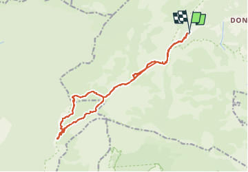

Length
17.4 km

Max alt
1782 m

Uphill gradient
816 m
Km-Effort
28 km

Min alt
1189 m

Downhill gradient
829 m
Boucle
Yes
Creation date :
2022-05-28 08:31:42.486
Updated on :
2022-05-28 17:06:18.121
5h46
Difficulty : Difficult

FREE GPS app for hiking
 SityTrail
IGN / Geographical institutes
SityTrail Plus
The world is yours!
About
Trail Walking of 17.4 km to be discovered at Auvergne-Rhône-Alpes, Isère, Chichilianne. This trail is proposed by Tof Tof.
Positioning
Country:
France
Region :
Auvergne-Rhône-Alpes
Department/Province :
Isère
Municipality :
Chichilianne
Location:
Unknown
Start:(Dec)
Start:(UTM)
699481 ; 4965623 (31T) N.
Comments