


Ailefroide

Bwattier
User
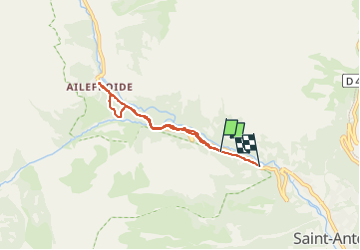

Length
5.1 km

Max alt
1512 m

Uphill gradient
123 m
Km-Effort
6.9 km

Min alt
1338 m

Downhill gradient
177 m
Boucle
No
Creation date :
2022-05-31 08:42:03.632
Updated on :
2022-05-31 10:29:32.805
1h25
Difficulty : Difficult

FREE GPS app for hiking
 SityTrail
IGN / Geographical institutes
SityTrail Plus
The world is yours!
About
Trail Walking of 5.1 km to be discovered at Provence-Alpes-Côte d'Azur, Hautes-Alpes, Vallouise-Pelvoux. This trail is proposed by Bwattier.
Positioning
Country:
France
Region :
Provence-Alpes-Côte d'Azur
Department/Province :
Hautes-Alpes
Municipality :
Vallouise-Pelvoux
Location:
Pelvoux
Start:(Dec)
Start:(UTM)
299913 ; 4972685 (32T) N.
Comments