


saint meme

cousam
User
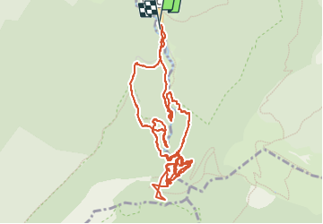

Length
6.9 km

Max alt
1422 m

Uphill gradient
824 m
Km-Effort
17.9 km

Min alt
863 m

Downhill gradient
822 m
Boucle
Yes
Creation date :
2022-06-02 07:19:40.968
Updated on :
2022-06-02 12:45:11.629
5h24
Difficulty : Difficult

FREE GPS app for hiking
 SityTrail
IGN / Geographical institutes
SityTrail Plus
The world is yours!
About
Trail Walking of 6.9 km to be discovered at Auvergne-Rhône-Alpes, Savoy, Saint-Pierre-d'Entremont. This trail is proposed by cousam.
Photos


Positioning
Country:
France
Region :
Auvergne-Rhône-Alpes
Department/Province :
Savoy
Municipality :
Saint-Pierre-d'Entremont
Location:
Unknown
Start:(Dec)
Start:(UTM)
726219 ; 5031551 (31T) N.
Comments