


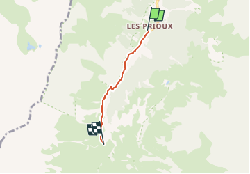
Vanoise-refuge du roc de la peche

m261212
User

Length
2.7 km

Max alt
1918 m

Uphill gradient
202 m
Km-Effort
4.8 km

Min alt
1714 m

Downhill gradient
1 m
Boucle
No
Creation date :
2022-06-02 15:44:10.021
Updated on :
2022-06-02 15:44:37.722
1h04
Difficulty : Easy

FREE GPS app for hiking
 SityTrail
IGN / Geographical institutes
SityTrail Plus
The world is yours!
About
Trail On foot of 2.7 km to be discovered at Auvergne-Rhône-Alpes, Savoy, Pralognan-la-Vanoise. This trail is proposed by m261212.
Positioning
Country:
France
Region :
Auvergne-Rhône-Alpes
Department/Province :
Savoy
Municipality :
Pralognan-la-Vanoise
Location:
Unknown
Start:(Dec)
Start:(UTM)
319926 ; 5024075 (32T) N.
Comments