Trail Walking La Tuque - La Tuque - Lac Lafrance - Photo
 catchou4
catchou4

User

© OpenStreetMap contributors
Length
Length
3.5 km
Max alt
Max alt
156 m
Uphill gradient
Uphill gradient
42 m
Km-Effort
Km-Effort  
4.1 km
Min alt
Min alt
124 m
Downhill gradient
Downhill gradient
42 m
Boucle
Boucle
Yes
Creation date :
2022-06-02 18:56:37.0
Updated on :
2022-06-02 19:55:35.898

(0 Reviews)

Walking
Walking
57m
Difficulty : Very easy

Scan this QR Code to open this trail in the SityTrail application

FREE GPS app for hiking

Logo SityTrail SityTrail

IGN / Geographical institutes

Download SityTrail from the App Store Download SityTrail from Google Play

Logo SityTrail SityTrail World

The world is yours!

Download SityTrail from the App Store Download SityTrail from Google Play Download SityTrail on Huawei AppGallery

About

Trail Walking of 3.5 km to be discovered at Quebec, La Tuque (agglomération), La Tuque. This trail is proposed by catchou4.

Description

Marche facile
!!! Balisage ne correspond pas au descriptif dans le fascicule « Escapades des sentiers »

Elevation profile

Photos

Positioning

Country:
Canada
Region :
Quebec
Department/Province :
La Tuque (agglomération)
Municipality :
La Tuque
Location:
Unknown
Start:(UTM)
666152 ; 5256169 (18T) N.

Trails nearby

Trail Walking La Tuque - marche - Photo
Walking
Jacques Cloutier

Walking

Easy
La Tuque, Quebec, La Tuque (agglomération), Canada
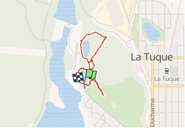
3.6 km | 3.9 km-effort
1h 46min
Yes


Close
My subscriptions