


G4 Pagolle gastellusare la chapelle

LouisROGER
User GUIDE
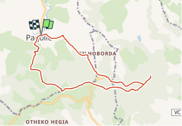

Length
9.2 km

Max alt
429 m

Uphill gradient
369 m
Km-Effort
14.1 km

Min alt
148 m

Downhill gradient
368 m
Boucle
Yes
Creation date :
2022-06-05 15:52:35.424
Updated on :
2022-06-05 16:00:57.408
3h12
Difficulty : Difficult

FREE GPS app for hiking
 SityTrail
IGN / Geographical institutes
SityTrail Plus
The world is yours!
About
Trail Walking of 9.2 km to be discovered at New Aquitaine, Pyrénées-Atlantiques, Pagolle. This trail is proposed by LouisROGER.
Description
tracé d'après Sity trail automatique
43 HKG E2 surement T2 R2
Positioning
Country:
France
Region :
New Aquitaine
Department/Province :
Pyrénées-Atlantiques
Municipality :
Pagolle
Location:
Unknown
Start:(Dec)
Start:(UTM)
663266 ; 4787715 (30T) N.
Comments