


Turckheim - Grand Hohnack

duchaine.nicolas
User
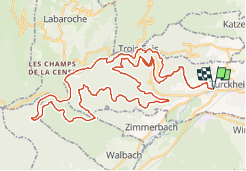

Length
32 km

Max alt
880 m

Uphill gradient
1040 m
Km-Effort
46 km

Min alt
247 m

Downhill gradient
1040 m
Boucle
Yes
Creation date :
2022-06-06 08:35:30.097
Updated on :
2022-06-06 14:29:50.203
2h50
Difficulty : Easy
2h50
Difficulty : Easy

FREE GPS app for hiking
 SityTrail
IGN / Geographical institutes
SityTrail Plus
The world is yours!
About
Trail Mountain bike of 32 km to be discovered at Grand Est, Haut-Rhin, Turckheim. This trail is proposed by duchaine.nicolas.
Positioning
Country:
France
Region :
Grand Est
Department/Province :
Haut-Rhin
Municipality :
Turckheim
Location:
Unknown
Start:(Dec)
Start:(UTM)
371100 ; 5327310 (32U) N.
Comments