


Gerderest reco G4 ou M1M2

mitch1952
User
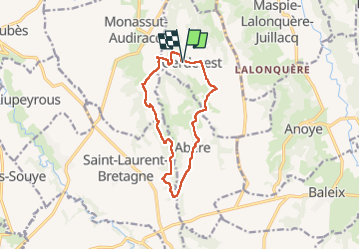

Length
12.3 km

Max alt
335 m

Uphill gradient
247 m
Km-Effort
15.6 km

Min alt
239 m

Downhill gradient
245 m
Boucle
Yes
Creation date :
2022-06-06 11:38:12.0
Updated on :
2022-06-06 15:32:55.755
2h52
Difficulty : Unknown

FREE GPS app for hiking
 SityTrail
IGN / Geographical institutes
SityTrail Plus
The world is yours!
About
Trail Walking of 12.3 km to be discovered at New Aquitaine, Pyrénées-Atlantiques, Gerderest. This trail is proposed by mitch1952.
Positioning
Country:
France
Region :
New Aquitaine
Department/Province :
Pyrénées-Atlantiques
Municipality :
Gerderest
Location:
Unknown
Start:(Dec)
Start:(UTM)
728317 ; 4810317 (30T) N.
Comments