Trail Cycle Vic-sur-Cère - vic sur cere  30KMS - Photo
 denel
denel

User

© OpenStreetMap contributors
Length
Length
31 km
Max alt
Max alt
1009 m
Uphill gradient
Uphill gradient
767 m
Km-Effort
Km-Effort  
42 km
Min alt
Min alt
662 m
Downhill gradient
Downhill gradient
768 m
Boucle
Boucle
Yes
Creation date :
2014-12-10 00:00:00.0
Updated on :
2014-12-10 00:00:00.0

(1 Reviews)

Cycle
Cycle
2h21
Difficulty : Medium

Scan this QR Code to open this trail in the SityTrail application

FREE GPS app for hiking

Logo SityTrail SityTrail

IGN / Geographical institutes

Download SityTrail from the App Store Download SityTrail from Google Play

Logo SityTrail SityTrail World

The world is yours!

Download SityTrail from the App Store Download SityTrail from Google Play Download SityTrail on Huawei AppGallery

About

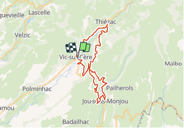
Trail Cycle of 31 km to be discovered at Auvergne-Rhône-Alpes, Cantal, Vic-sur-Cère. This trail is proposed by denel.

Elevation profile

Positioning

Country:
France
Region :
Auvergne-Rhône-Alpes
Department/Province :
Cantal
Municipality :
Vic-sur-Cère
Location:
Unknown
Start:(UTM)
470624 ; 4980628 (31T) N.

Comments

Please log in to post a review or rate the element


Très beau parcours mais avec une grosse erreur qui donne le choix entre un sentier en impasse ou un franchissement quasi impossible de route nationale. C’est dommage et ça nous a fait perdre une demi-heure. La solution est d’aller jusqu’à Thiezac,


Trails nearby

Trail Walking Thiézac - La Porte du Lion - Thiézac - Photo
Walking
tracegps

Walking

Medium
(2)
Thiézac, Auvergne-Rhône-Alpes, Cantal, France
6.6 km | 10.5 km-effort
3h 0min
Yes
Trail Walking Polminhac - Polminhac - Autour du donjon - Photo
Walking
tracegps

Walking

Easy
(1)
Polminhac, Auvergne-Rhône-Alpes, Cantal, France
5.2 km | 8.6 km-effort
2h 0min
Yes
Trail Walking Thiézac - La porte du Lion - Thiézac - Photo
Walking
tracegps

Walking

Medium
(2)
Thiézac, Auvergne-Rhône-Alpes, Cantal, France
7.6 km | 11.5 km-effort
3h 30min
Yes
Trail Walking Pailherols - Pailherols chapelle du Cantal  - Photo
Walking
GUIDE
antignacs

Walking

Medium
Pailherols, Auvergne-Rhône-Alpes, Cantal, France
21 km | 29 km-effort
5h 29min
Yes
Trail Walking Vic-sur-Cère - Pas de Cère- cascade de Gourdole - Photo
Walking
crocau

Walking

Very easy
Vic-sur-Cère, Auvergne-Rhône-Alpes, Cantal, France
4.7 km | 6.6 km-effort
2h 0min
Yes
Trail Walking Thiézac - Puy de la poche  - Photo
Walking
nadd73

Walking

Easy
Thiézac, Auvergne-Rhône-Alpes, Cantal, France
13.1 km | 23 km-effort
3h 14min
Yes
Trail Walking Thiézac - Les Gorges du Pas de Cère - Photo
Walking
VacheKiri67

Walking

Easy
Thiézac, Auvergne-Rhône-Alpes, Cantal, France
4.8 km | 6.8 km-effort
2h 21min
Yes
Trail Walking Lascelle - Arbre de quenouille, rocher saint curial, col de berganti - Photo
Walking
impradine

Walking

Easy
Lascelle, Auvergne-Rhône-Alpes, Cantal, France
12.8 km | 19 km-effort
3h 37min
Yes
Trail Walking Pailherols - rando sentier des  gentianes - Photo
Walking
Sandrine 15

Walking

Medium
Pailherols, Auvergne-Rhône-Alpes, Cantal, France
13.1 km | 17.7 km-effort
3h 20min
Yes


Close
My subscriptions