Trail Walking Polminhac - Polminhac - Autour du donjon - Photo

Polminhac - Autour du donjon

 tracegps
tracegps

User

© OpenStreetMap contributors
Length
Length
5.2 km
Max alt
Max alt
894 m
Uphill gradient
Uphill gradient
252 m
Km-Effort
Km-Effort  
8.6 km
Min alt
Min alt
659 m
Downhill gradient
Downhill gradient
251 m
Boucle
Boucle
Yes
Creation date :
2014-12-10 00:00:00.0
Updated on :
2014-12-10 00:00:00.0

(1 Reviews)

Walking
Walking
2h00
Difficulty : Easy

Scan this QR Code to open this trail in the SityTrail application

FREE GPS app for hiking

Logo SityTrail SityTrail

IGN / Geographical institutes

Download SityTrail from the App Store Download SityTrail from Google Play

Logo SityTrail SityTrail World

The world is yours!

Download SityTrail from the App Store Download SityTrail from Google Play Download SityTrail on Huawei AppGallery

About

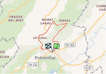
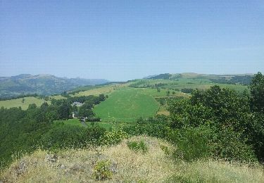
Trail Walking of 5.2 km to be discovered at Auvergne-Rhône-Alpes, Cantal, Polminhac. This trail is proposed by tracegps.

Description

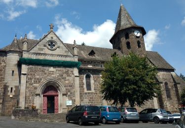
Un circuit à faire en famille, pour découvrir le château de Pesteils et son donjon sous toutes ses faces ! Circuit de 6,5km, balisage bleu. Durée : 2h Dénivelé : 216 m (Attention : au départ, grimpée d'un 1km en sous bois). Départ depuis le Bureau de Tourisme, à côté de l'église. Traverser la RN122 et prendre la rue de Kayrie. Chiens déconseillés, en raison des troupeaux de vaches en pâture.

Elevation profile

Photos

Positioning

Country:
France
Region :
Auvergne-Rhône-Alpes
Department/Province :
Cantal
Municipality :
Polminhac
Location:
Unknown
Start:(UTM)
466590 ; 4977663 (31T) N.

Comments

Please log in to post a review or rate the element


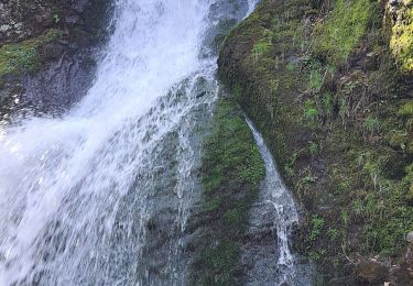
balade rres sympa. un peu raide au départ.


Trails nearby

Trail Walking Vic-sur-Cère - La Via Arverna (Vic-sur-Cère - Aurillac) - Photo
Walking
tracegps

Walking

Difficult
Vic-sur-Cère, Auvergne-Rhône-Alpes, Cantal, France
23 km | 32 km-effort
7h 0min
No
Trail Running Vic-sur-Cère - vic sur cere - Photo
Running
lbahier

Running

Medium
Vic-sur-Cère, Auvergne-Rhône-Alpes, Cantal, France
11.7 km | 18.9 km-effort
1h 37min
Yes
Trail Walking Vic-sur-Cère - 06/1 avil 2023  - Photo
Walking
habby

Walking

Very easy
Vic-sur-Cère, Auvergne-Rhône-Alpes, Cantal, France
5.7 km | 9.7 km-effort
39min
Yes
Trail Walking Vic-sur-Cère - Grotte des Anglais - Photo
Walking
alexisml

Walking

Difficult
Vic-sur-Cère, Auvergne-Rhône-Alpes, Cantal, France
8.3 km | 15.6 km-effort
2h 36min
No
Trail Running Vic-sur-Cère - boucle vic sur cere - rocher du pendu - Photo
Running
lbahier

Running

Medium
Vic-sur-Cère, Auvergne-Rhône-Alpes, Cantal, France
12.1 km | 19.4 km-effort
1h 38min
No
Trail Walking Vic-sur-Cère - La Grotte des Anglais - Vic sur Cère - Photo
Walking
tracegps

Walking

Medium
Vic-sur-Cère, Auvergne-Rhône-Alpes, Cantal, France
6.3 km | 12.8 km-effort
2h 45min
Yes
Trail Mountain bike Saint-Simon - DC43 km - Photo
Mountain bike
Midego

Mountain bike

Very difficult
Saint-Simon, Auvergne-Rhône-Alpes, Cantal, France
42 km | 66 km-effort
4h 22min
No
Trail Walking Vic-sur-Cère - plateau du Coyan - Photo
Walking
Jean-Marie Bousquet

Walking

Medium
Vic-sur-Cère, Auvergne-Rhône-Alpes, Cantal, France
11.2 km | 18.5 km-effort
2h 38min
Yes
Trail Walking Saint-Simon - Oyez - Photo
Walking
Jean-Marie Bousquet

Walking

Medium
Saint-Simon, Auvergne-Rhône-Alpes, Cantal, France
12.2 km | 17.2 km-effort
2h 39min
Yes


Close
My subscriptions