


Traversée du Vercors

jpduc
User
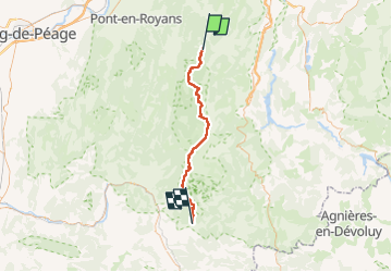

Length
54 km

Max alt
2328 m

Uphill gradient
2212 m
Km-Effort
85 km

Min alt
583 m

Downhill gradient
2847 m
Boucle
No
Creation date :
2022-06-08 05:39:42.0
Updated on :
2022-06-11 16:07:43.9
20h02
Difficulty : Very difficult

FREE GPS app for hiking
 SityTrail
IGN / Geographical institutes
SityTrail Plus
The world is yours!
About
Trail Walking of 54 km to be discovered at Auvergne-Rhône-Alpes, Isère, Corrençon-en-Vercors. This trail is proposed by jpduc.
Description
Villard de Lans - Châtillon en Diois
Positioning
Country:
France
Region :
Auvergne-Rhône-Alpes
Department/Province :
Isère
Municipality :
Corrençon-en-Vercors
Location:
Unknown
Start:(Dec)
Start:(UTM)
697910 ; 4986852 (31T) N.
Comments