Trail Walking Celles-sur-Plaine - Tête du coquin  - Photo
© OpenStreetMap contributors
Length
Length
11.6 km
Max alt
Max alt
825 m
Uphill gradient
Uphill gradient
556 m
Km-Effort
Km-Effort  
19 km
Min alt
Min alt
383 m
Downhill gradient
Downhill gradient
545 m
Boucle
Boucle
Yes
Creation date :
2022-06-14 08:04:43.871
Updated on :
2022-06-15 11:07:04.65

(0 Reviews)

Walking
Walking
2h15
Difficulty : Very difficult

Scan this QR Code to open this trail in the SityTrail application

FREE GPS app for hiking

Logo SityTrail SityTrail

IGN / Geographical institutes

Download SityTrail from the App Store Download SityTrail from Google Play

Logo SityTrail SityTrail World

The world is yours!

Download SityTrail from the App Store Download SityTrail from Google Play Download SityTrail on Huawei AppGallery

About

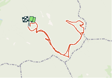
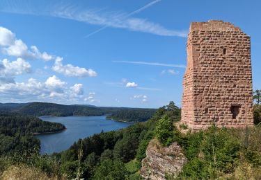
Trail Walking of 11.6 km to be discovered at Grand Est, Vosges, Celles-sur-Plaine. This trail is proposed by didier cornelius.

Description

randonner de 11,6 km 5km de monté 5km de descente .

Elevation profile

Photos

Positioning

Country:
France
Region :
Grand Est
Department/Province :
Vosges
Municipality :
Celles-sur-Plaine
Location:
Unknown
Start:(UTM)
350693 ; 5368580 (32U) N.

Trails nearby

Trail Walking Pierre-Percée - Tour du lac du Vieux-Pré - Photo
Walking
VacheKiri67

Walking

Difficult
(2)
Pierre-Percée, Grand Est, Meurthe-et-Moselle, France
30 km | 38 km-effort
8h 35min
Yes
Trail Walking Senones - roche de la mère henry - Photo
Walking
remysimon

Walking

Easy
(1)
Senones, Grand Est, Vosges, France
9.6 km | 13.3 km-effort
2h 46min
No
Trail Walking Pierre-Percée - pierre percée, circuit des roches, etc... - Photo
Walking
mitch1915

Walking

Medium
(1)
Pierre-Percée, Grand Est, Meurthe-et-Moselle, France
20 km | 28 km-effort
8h 0min
Yes
Trail Walking Badonviller - 2023-07-22 Marche Bivouac Lac de la pierre percee - Photo
Walking
GUIDE
holtzv

Walking

Easy
Badonviller, Grand Est, Meurthe-et-Moselle, France
21 km | 27 km-effort
6h 35min
No
Trail Horseback riding Badonviller - Lac de Pierre Percée 25 km - Photo
Horseback riding
ACPL

Horseback riding

Difficult
(1)
Badonviller, Grand Est, Meurthe-et-Moselle, France
25 km | 32 km-effort
4h 13min
Yes
Trail Mountain bike Celles-sur-Plaine - sortie vtt du 24102019 celles sur plaine  - Photo
Mountain bike
GUIDE
fabwin

Mountain bike

Difficult
Celles-sur-Plaine, Grand Est, Vosges, France
21 km | 30 km-effort
2h 27min
Yes
Trail Walking Allarmont - 2019-06-08 Marche Allarmont et ses rochers - Photo
Walking
GUIDE
holtzv

Walking

Very easy
Allarmont, Grand Est, Vosges, France
10.7 km | 16.5 km-effort
2h 55min
Yes
Trail Walking Badonviller - La Vierge Clarisse VOSGES - Photo
Walking
Dominique48

Walking

Difficult
Badonviller, Grand Est, Meurthe-et-Moselle, France
9.3 km | 13.8 km-effort
4h 31min
No
Trail Walking Moussey - 2023-03-25 Marche Moussey Sentier des Passeurs Haute Loge - Photo
Walking
GUIDE
holtzv

Walking

Medium
Moussey, Grand Est, Vosges, France
19.2 km | 28 km-effort
5h 46min
Yes


Close
My subscriptions