


col de la perche

Liebeaux
User
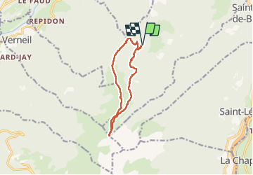

Length
10.8 km

Max alt
1990 m

Uphill gradient
610 m
Km-Effort
18.9 km

Min alt
1517 m

Downhill gradient
614 m
Boucle
Yes
Creation date :
2022-06-16 07:06:58.563
Updated on :
2022-06-16 14:29:37.041
6h19
Difficulty : Difficult

FREE GPS app for hiking
 SityTrail
IGN / Geographical institutes
SityTrail Plus
The world is yours!
About
Trail Walking of 10.8 km to be discovered at Auvergne-Rhône-Alpes, Savoy, Saint-Alban-d'Hurtières. This trail is proposed by Liebeaux.
Positioning
Country:
France
Region :
Auvergne-Rhône-Alpes
Department/Province :
Savoy
Municipality :
Saint-Alban-d'Hurtières
Location:
Unknown
Start:(Dec)
Start:(UTM)
283263 ; 5037723 (32T) N.
Comments