


bauges

Tof Tof
User
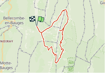

Length
18.3 km

Max alt
1902 m

Uphill gradient
1290 m
Km-Effort
35 km

Min alt
1100 m

Downhill gradient
1291 m
Boucle
Yes
Creation date :
2022-06-18 08:39:38.636
Updated on :
2022-06-19 11:16:41.164
7h42
Difficulty : Difficult

FREE GPS app for hiking
 SityTrail
IGN / Geographical institutes
SityTrail Plus
The world is yours!
About
Trail Walking of 18.3 km to be discovered at Auvergne-Rhône-Alpes, Savoy, Bellecombe-en-Bauges. This trail is proposed by Tof Tof.
Positioning
Country:
France
Region :
Auvergne-Rhône-Alpes
Department/Province :
Savoy
Municipality :
Bellecombe-en-Bauges
Location:
Unknown
Start:(Dec)
Start:(UTM)
279702 ; 5068372 (32T) N.
Comments