


Parc de Mandavit - Malartic - Gradignan

bedous
User
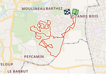

Length
7.4 km

Max alt
41 m

Uphill gradient
72 m
Km-Effort
8.3 km

Min alt
17 m

Downhill gradient
70 m
Boucle
Yes
Creation date :
2022-06-22 12:25:44.239
Updated on :
2022-06-22 16:12:22.635
1h54
Difficulty : Easy

FREE GPS app for hiking
 SityTrail
IGN / Geographical institutes
SityTrail Plus
The world is yours!
About
Trail Walking of 7.4 km to be discovered at New Aquitaine, Gironde, Gradignan. This trail is proposed by bedous.
Description
Rando sous bois par pistes et sentiers. Pour tous !
Positioning
Country:
France
Region :
New Aquitaine
Department/Province :
Gironde
Municipality :
Gradignan
Location:
Unknown
Start:(Dec)
Start:(UTM)
690346 ; 4959915 (30T) N.
Comments