


les chaudières

nordan
User

Length
16.6 km

Max alt
2048 m

Uphill gradient
1140 m
Km-Effort
32 km

Min alt
1235 m

Downhill gradient
1139 m
Boucle
Yes
Creation date :
2022-06-26 07:17:55.554
Updated on :
2022-06-26 14:40:01.339
7h20
Difficulty : Medium

FREE GPS app for hiking
 SityTrail
IGN / Geographical institutes
SityTrail Plus
The world is yours!
About
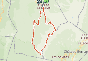
Trail Walking of 16.6 km to be discovered at Auvergne-Rhône-Alpes, Isère, Corrençon-en-Vercors. This trail is proposed by nordan.
Positioning
Country:
France
Region :
Auvergne-Rhône-Alpes
Department/Province :
Isère
Municipality :
Corrençon-en-Vercors
Location:
Unknown
Start:(Dec)
Start:(UTM)
699273 ; 4988319 (31T) N.
Comments