


EXT-65 Issenheim-01

Specialized77
User GUIDE
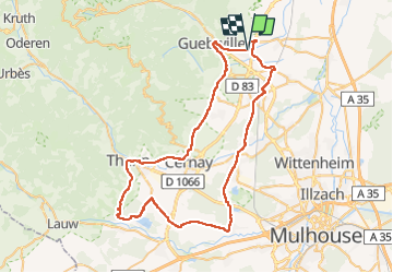

Length
65 km

Max alt
415 m

Uphill gradient
552 m
Km-Effort
73 km

Min alt
219 m

Downhill gradient
551 m
Boucle
Yes
Creation date :
2022-07-01 11:15:14.841
Updated on :
2022-07-07 18:50:58.379
3h54
Difficulty : Easy

FREE GPS app for hiking
 SityTrail
IGN / Geographical institutes
SityTrail Plus
The world is yours!
About
Trail Road bike of 65 km to be discovered at Grand Est, Haut-Rhin, Issenheim. This trail is proposed by Specialized77.
Photos


Positioning
Country:
France
Region :
Grand Est
Department/Province :
Haut-Rhin
Municipality :
Issenheim
Location:
Unknown
Start:(Dec)
Start:(UTM)
369500 ; 5307041 (32T) N.
Comments