![](/images/other/stat-length.png)
![Trail Walking Beauraing - WINENNE _ [ BEAURAING ] _ NA _ 2/07/2022 - Photo](https://media.geolcdn.com/t/1900/400/ext.pjpeg?maxdim=2&url=https%3A%2F%2Fmedia.geolcdn.com%2Ff%2F082e8942-4c7e-4503-a878-ed6f33617019.jpg)
WINENNE _ [ BEAURAING ] _ NA _ 2/07/2022
jeangulu
User
![Length](/images/other/stat-length.png)
Length
21 km
![Max alt](https://static1.geolcdn.com/siteimages/upload/files/1508320355ic_sort_altitude_max_24dp.png)
Max alt
359 m
![Uphill gradient](https://static1.geolcdn.com/siteimages/upload/files/1508320355ic_sort_den_pos_24dp.png)
Uphill gradient
434 m
![Km-Effort](/images/other/stat-length.png)
Km-Effort
27 km
![Min alt](https://static1.geolcdn.com/siteimages/upload/files/1508320355ic_sort_altitude_min_24dp.png)
Min alt
224 m
![Downhill gradient](https://static1.geolcdn.com/siteimages/upload/files/1508320355ic_sort_den_neg_24dp.png)
Downhill gradient
433 m
![Boucle](https://static1.geolcdn.com/siteimages/upload/files/16400158638029165_repeat_loop_refresh_sync_direction_icon.png)
Boucle
Yes
Creation date :
2022-07-02 07:58:24.612
Updated on :
2022-07-02 13:35:19.505
![Walking](https://static1.geolcdn.com/sitytour/trail-icons/101.png)
5h33
Difficulty : Medium
![Scan this QR Code to open this trail in the SityTrail application](https://capi.geolives.com/qq0zvz2zws4bq2lad0pu/sitytour/trails/3301809/qr.png?size=200)
FREE GPS app for hiking
About
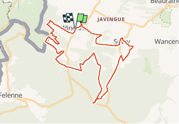
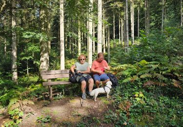
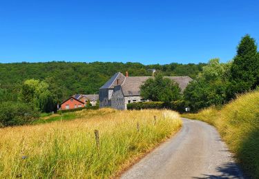
Trail Walking of 21 km to be discovered at Wallonia, Namur, Beauraing. This trail is proposed by jeangulu.
Description
Point de départ : Salle ' Les Ouvriers Courageuse " - Rue des Ardennes, 414 - 5570 WINENNE [ BEAURAING ].
Organisateur : NA 012 - LES PANARDS WINENNOIS
Positioning
Country:
Belgium
Region :
Wallonia
Department/Province :
Namur
Municipality :
Beauraing
Location:
Unknown
Start:(Dec)
Start:(UTM)
635481 ; 5551180 (31U) N.
Comments
Trails nearby
![Trail Walking Beauraing - Winenne - Nature: trip to the countryside - Photo](https://media.geolcdn.com/t/375/260/ext.jpg?maxdim=2&url=https%3A%2F%2Fservices.sitytrail.com%2FGeolivesWS%2FDownloadMedia.ashx%3FTrailID%3D208730%26Media%3Dec2b8399-61b2-47f0-8c4e-ffe9506b5f79.jpg)
![Walking Walking](https://static1.geolcdn.com/sitytour/trail-icons/101.png)
Winenne - Nature: trip to the countryside
Walking
Difficult
(7)
Beauraing,
Wallonia,
Namur,
Belgium
![](/images/other/stat-length.png)
20 km | 26 km-effort
6h 0min
![](https://static1.geolcdn.com/siteimages/upload/files/16400158638029165_repeat_loop_refresh_sync_direction_icon.png)
Yes
![Trail Walking Beauraing - RB-Na-28-En Famenne occidentale - Photo](https://media.geolcdn.com/t/375/260/ext.jpg?maxdim=2&url=https%3A%2F%2Fmedia.geolcdn.com%2Ff%2F3eaaa04f-7eff-4d10-b520-576c4173c26c.JPG)
![Walking Walking](https://static1.geolcdn.com/sitytour/trail-icons/101.png)
RB-Na-28-En Famenne occidentale
Walking
Very difficult
(5)
Beauraing,
Wallonia,
Namur,
Belgium
![](/images/other/stat-length.png)
19.4 km | 24 km-effort
5h 33min
![](https://static1.geolcdn.com/siteimages/upload/files/16400158638029165_repeat_loop_refresh_sync_direction_icon.png)
Yes
![Trail Walking Beauraing - Javingue-Sevry - Roadbook discovering villages & landscapes - Photo](https://media.geolcdn.com/t/375/260/ext.jpg?maxdim=2&url=https%3A%2F%2Fservices.sitytrail.com%2FGeolivesWS%2FDownloadMedia.ashx%3FTrailID%3D230063%26Media%3D65d10601-99c2-4ec7-afa5-e6b7caea9bd6.jpg)
![Walking Walking](https://static1.geolcdn.com/sitytour/trail-icons/101.png)
Javingue-Sevry - Roadbook discovering villages & landscapes
Walking
Easy
(6)
Beauraing,
Wallonia,
Namur,
Belgium
![](/images/other/stat-length.png)
7.7 km | 10.2 km-effort
2h 0min
![](https://static1.geolcdn.com/siteimages/upload/files/16400158638029165_repeat_loop_refresh_sync_direction_icon.png)
Yes
![Trail Walking Beauraing - Beauraing - Discover its natural and architectural treasures - Photo](https://media.geolcdn.com/t/375/260/ext.jpg?maxdim=2&url=https%3A%2F%2Fservices.sitytrail.com%2FGeolivesWS%2FDownloadMedia.ashx%3FTrailID%3D179304%26Media%3D8042c99a-cbb1-4b71-ba1e-520d449245b8.jpg)
![Walking Walking](https://static1.geolcdn.com/sitytour/trail-icons/101.png)
Beauraing - Discover its natural and architectural treasures
Walking
Easy
(5)
Beauraing,
Wallonia,
Namur,
Belgium
![](/images/other/stat-length.png)
6.5 km | 8.6 km-effort
1h 43min
![](https://static1.geolcdn.com/siteimages/upload/files/16400158638029165_repeat_loop_refresh_sync_direction_icon.png)
Yes
![Trail Walking Givet - Balade à Givet - Photo](https://media.geolcdn.com/t/375/260/ext.jpg?maxdim=2&url=https%3A%2F%2Fservices.sitytrail.com%2FGeolivesWS%2FDownloadMedia.ashx%3FTrailID%3D110616%26Media%3D6179_5.jpg)
![Walking Walking](https://static1.geolcdn.com/sitytour/trail-icons/101.png)
Balade à Givet
Walking
Medium
(3)
Givet,
Grand Est,
Ardennes,
France
![](/images/other/stat-length.png)
8 km | 9.4 km-effort
2h 0min
![](https://static1.geolcdn.com/siteimages/upload/files/16400158638029165_repeat_loop_refresh_sync_direction_icon.png)
Yes
![Trail Walking Givet - Promenade sur les remparts du Mont d'Haurs - Photo](https://media.geolcdn.com/t/375/260/ext.jpg?maxdim=2&url=https%3A%2F%2Fservices.sitytrail.com%2FGeolivesWS%2FDownloadMedia.ashx%3FTrailID%3D108905%26Media%3D2570_6.jpg)
![Walking Walking](https://static1.geolcdn.com/sitytour/trail-icons/101.png)
Promenade sur les remparts du Mont d'Haurs
Walking
Medium
(3)
Givet,
Grand Est,
Ardennes,
France
![](/images/other/stat-length.png)
5.1 km | 6.7 km-effort
2h 0min
![](https://static1.geolcdn.com/siteimages/upload/files/16400158638029165_repeat_loop_refresh_sync_direction_icon.png)
Yes
![Trail Mountain bike Beauraing - Winenne - Nature: trip to the countryside - Photo](https://media.geolcdn.com/t/375/260/ext.jpg?maxdim=2&url=https%3A%2F%2Fservices.sitytrail.com%2FGeolivesWS%2FDownloadMedia.ashx%3FTrailID%3D225225%26Media%3D30a4a7fc-abda-4afa-ad3f-06c878f2db6f.jpg)
![Mountain bike Mountain bike](https://static1.geolcdn.com/sitytour/trail-icons/202.png)
Winenne - Nature: trip to the countryside
Mountain bike
Medium
(3)
Beauraing,
Wallonia,
Namur,
Belgium
![](/images/other/stat-length.png)
20 km | 26 km-effort
1h 41min
![](https://static1.geolcdn.com/siteimages/upload/files/16400158638029165_repeat_loop_refresh_sync_direction_icon.png)
Yes
![Trail Walking Beauraing - Balade dans la forêt de Felenne-Beauraing - Photo](https://media.geolcdn.com/t/375/260/ext.jpg?maxdim=2&url=https%3A%2F%2Fmedia.geolcdn.com%2Ff%2Fe48c272a-3458-4139-8269-670b69d7c90a.jpg)
![Walking Walking](https://static1.geolcdn.com/sitytour/trail-icons/101.png)
Balade dans la forêt de Felenne-Beauraing
Walking
Difficult
Beauraing,
Wallonia,
Namur,
Belgium
![](/images/other/stat-length.png)
10.5 km | 14.4 km-effort
3h 16min
![](https://static1.geolcdn.com/siteimages/upload/files/16400158638029165_repeat_loop_refresh_sync_direction_icon.png)
Yes
![Trail Walking Beauraing - Balade de Dion à Winenne - Beauraing - Photo](https://media.geolcdn.com/t/375/260/ext.jpg?maxdim=2&url=https%3A%2F%2Fmedia.geolcdn.com%2Ff%2F5c1dc6e2-7e96-43cd-a912-ceabbaabe8bc.jpeg)
![Walking Walking](https://static1.geolcdn.com/sitytour/trail-icons/101.png)
Balade de Dion à Winenne - Beauraing
Walking
Medium
(1)
Beauraing,
Wallonia,
Namur,
Belgium
![](/images/other/stat-length.png)
6.5 km | 8.5 km-effort
1h 55min
![](https://static1.geolcdn.com/siteimages/upload/files/16400158638029165_repeat_loop_refresh_sync_direction_icon.png)
Yes