


la montagne

mcterret
User
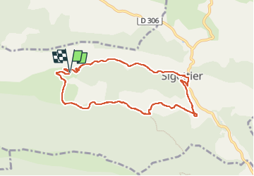

Length
8.7 km

Max alt
1040 m

Uphill gradient
339 m
Km-Effort
13.2 km

Min alt
721 m

Downhill gradient
334 m
Boucle
Yes
Creation date :
2022-07-03 05:59:19.532
Updated on :
2022-07-03 09:46:01.443
2h38
Difficulty : Easy

FREE GPS app for hiking
 SityTrail
IGN / Geographical institutes
SityTrail Plus
The world is yours!
About
Trail Walking of 8.7 km to be discovered at Provence-Alpes-Côte d'Azur, Hautes-Alpes, Sigottier. This trail is proposed by mcterret.
Positioning
Country:
France
Region :
Provence-Alpes-Côte d'Azur
Department/Province :
Hautes-Alpes
Municipality :
Sigottier
Location:
Unknown
Start:(Dec)
Start:(UTM)
711988 ; 4925915 (31T) N.
Comments