


promenade du COVID

dcharbonnier
User

Length
9.7 km

Max alt
1796 m

Uphill gradient
396 m
Km-Effort
15 km

Min alt
1497 m

Downhill gradient
398 m
Boucle
No
Creation date :
2022-07-07 12:42:32.35
Updated on :
2022-07-07 15:23:18.902
2h39
Difficulty : Medium

FREE GPS app for hiking
 SityTrail
IGN / Geographical institutes
SityTrail Plus
The world is yours!
About
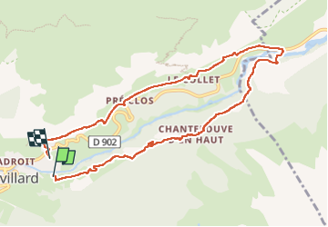
Trail Walking of 9.7 km to be discovered at Auvergne-Rhône-Alpes, Savoy, Val-Cenis. This trail is proposed by dcharbonnier.
Description
Chantelouve, le Collet St Madeleine.
Positioning
Country:
France
Region :
Auvergne-Rhône-Alpes
Department/Province :
Savoy
Municipality :
Val-Cenis
Location:
Lanslevillard
Start:(Dec)
Start:(UTM)
337030 ; 5017203 (32T) N.
Comments