


Gr10 suite Arles sur tech

georghinio
User

Length
27 km

Max alt
2175 m

Uphill gradient
2421 m
Km-Effort
53 km

Min alt
309 m

Downhill gradient
580 m
Boucle
No
Creation date :
2022-07-07 05:08:30.0
Updated on :
2022-07-12 11:54:22.93
12h07
Difficulty : Very difficult

FREE GPS app for hiking
 SityTrail
IGN / Geographical institutes
SityTrail Plus
The world is yours!
About
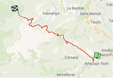
Trail Walking of 27 km to be discovered at Occitania, Pyrénées-Orientales, Arles-sur-Tech. This trail is proposed by georghinio.
Description
Départ d'Arles sur Tech jusqu'au refuge des Cortalets, rando longue et difficile car beaucoup de dénivelé mais de très beaux points de vues!
Positioning
Country:
France
Region :
Occitania
Department/Province :
Pyrénées-Orientales
Municipality :
Arles-sur-Tech
Location:
Unknown
Start:(Dec)
Start:(UTM)
469286 ; 4700725 (31T) N.
Comments