


Chalet reynaud Mont ventoux

Roger Philippe Wallez
User GUIDE
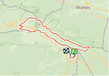

Length
20 km

Max alt
1910 m

Uphill gradient
929 m
Km-Effort
33 km

Min alt
1381 m

Downhill gradient
925 m
Boucle
Yes
Creation date :
2022-07-03 07:43:13.0
Updated on :
2022-07-10 07:36:13.093
7h32
Difficulty : Very difficult

FREE GPS app for hiking
 SityTrail
IGN / Geographical institutes
SityTrail Plus
The world is yours!
About
Trail Walking of 20 km to be discovered at Provence-Alpes-Côte d'Azur, Vaucluse, Bédoin. This trail is proposed by Roger Philippe Wallez.
Positioning
Country:
France
Region :
Provence-Alpes-Côte d'Azur
Department/Province :
Vaucluse
Municipality :
Bédoin
Location:
Unknown
Start:(Dec)
Start:(UTM)
685415 ; 4891352 (31T) N.
Comments