


GR10T2 10/07/22

LouisROGER
User GUIDE
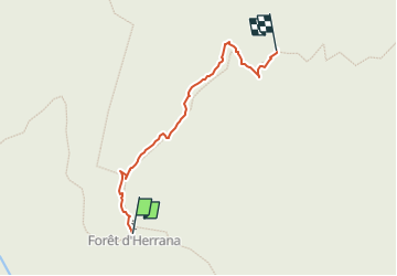

Length
580 m

Max alt
1192 m

Uphill gradient
56 m
Km-Effort
1.1 km

Min alt
1127 m

Downhill gradient
0 m
Boucle
No
Creation date :
2022-07-10 12:52:48.599
Updated on :
2022-07-14 16:28:11.807
24m
Difficulty : Easy

FREE GPS app for hiking
 SityTrail
IGN / Geographical institutes
SityTrail Plus
The world is yours!
About
Trail Walking of 580 m to be discovered at New Aquitaine, Pyrénées-Atlantiques, Laruns. This trail is proposed by LouisROGER.
Description
reprise balisage
Positioning
Country:
France
Region :
New Aquitaine
Department/Province :
Pyrénées-Atlantiques
Municipality :
Laruns
Location:
Unknown
Start:(Dec)
Start:(UTM)
711071 ; 4753727 (30T) N.
Comments