


montee col lac Bramant

verozerr
User
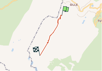

Length
2.7 km

Max alt
2540 m

Uphill gradient
399 m
Km-Effort
6.7 km

Min alt
2128 m

Downhill gradient
14 m
Boucle
No
Creation date :
2022-07-09 07:10:43.428
Updated on :
2022-07-11 14:26:28.978
2h15
Difficulty : Medium

FREE GPS app for hiking
 SityTrail
IGN / Geographical institutes
SityTrail Plus
The world is yours!
About
Trail Walking of 2.7 km to be discovered at Auvergne-Rhône-Alpes, Savoy, Saint-Sorlin-d'Arves. This trail is proposed by verozerr.
Description
vue sur le lac Bramant
Positioning
Country:
France
Region :
Auvergne-Rhône-Alpes
Department/Province :
Savoy
Municipality :
Saint-Sorlin-d'Arves
Location:
Unknown
Start:(Dec)
Start:(UTM)
279535 ; 5011853 (32T) N.
Comments