


Col de Sollières

Clo0413
User
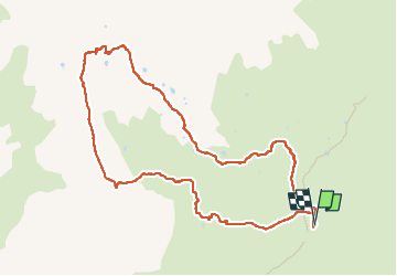

Length
10.6 km

Max alt
2686 m

Uphill gradient
570 m
Km-Effort
18.2 km

Min alt
2115 m

Downhill gradient
572 m
Boucle
Yes
Creation date :
2022-07-14 06:58:47.575
Updated on :
2022-07-16 20:36:00.9
3h43
Difficulty : Medium

FREE GPS app for hiking
 SityTrail
IGN / Geographical institutes
SityTrail Plus
The world is yours!
About
Trail Walking of 10.6 km to be discovered at Auvergne-Rhône-Alpes, Savoy, Val-Cenis. This trail is proposed by Clo0413.
Positioning
Country:
France
Region :
Auvergne-Rhône-Alpes
Department/Province :
Savoy
Municipality :
Val-Cenis
Location:
Bramans
Start:(Dec)
Start:(UTM)
333954 ; 5009353 (32T) N.
Comments