


Col de Sollières, Mont Froid

Clo0413
User
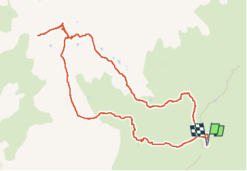

Length
12.7 km

Max alt
2791 m

Uphill gradient
682 m
Km-Effort
22 km

Min alt
2115 m

Downhill gradient
683 m
Boucle
Yes
Creation date :
2022-07-14 06:58:23.637
Updated on :
2022-07-16 20:35:06.215
6h07
Difficulty : Medium

FREE GPS app for hiking
 SityTrail
IGN / Geographical institutes
SityTrail Plus
The world is yours!
About
Trail Walking of 12.7 km to be discovered at Auvergne-Rhône-Alpes, Savoy, Val-Cenis. This trail is proposed by Clo0413.
Positioning
Country:
France
Region :
Auvergne-Rhône-Alpes
Department/Province :
Savoy
Municipality :
Val-Cenis
Location:
Bramans
Start:(Dec)
Start:(UTM)
333952 ; 5009351 (32T) N.
Comments