Trail Road bike Mûrs-Erigné - Murs Erigné la Loire - Photo
 FOUCAULT
FOUCAULT

User

© OpenStreetMap contributors
Length
Length
17.6 km
Max alt
Max alt
47 m
Uphill gradient
Uphill gradient
172 m
Km-Effort
Km-Effort  
19.9 km
Min alt
Min alt
14 m
Downhill gradient
Downhill gradient
172 m
Boucle
Boucle
Yes
Creation date :
2022-07-16 09:34:09.0
Updated on :
2022-07-16 11:01:51.467

(0 Reviews)

Road bike
Road bike
1h11
Difficulty : Unknown

Scan this QR Code to open this trail in the SityTrail application

FREE GPS app for hiking

Logo SityTrail SityTrail

IGN / Geographical institutes

Download SityTrail from the App Store Download SityTrail from Google Play

Logo SityTrail SityTrail World

The world is yours!

Download SityTrail from the App Store Download SityTrail from Google Play Download SityTrail on Huawei AppGallery

About

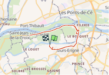
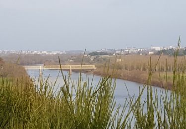
Trail Road bike of 17.6 km to be discovered at Pays de la Loire, Maine-et-Loire, Mûrs-Erigné. This trail is proposed by FOUCAULT.

Description

Le samedi 16 juillet 2022

Elevation profile

Positioning

Country:
France
Region :
Pays de la Loire
Department/Province :
Maine-et-Loire
Municipality :
Mûrs-Erigné
Location:
Unknown
Start:(UTM)
684403 ; 5252902 (30T) N.

Trails nearby

Trail Walking Bouchemaine - la pointe bouchemaine  - Photo
Walking
louis49

Walking

Difficult
Bouchemaine, Pays de la Loire, Maine-et-Loire, France
11.5 km | 13 km-effort
2h 51min
Yes
Trail Walking Bouchemaine - Bouchemaine, abbaye de La Baumette  - Photo
Walking
louis49

Walking

Medium
Bouchemaine, Pays de la Loire, Maine-et-Loire, France
21 km | 24 km-effort
2h 31min
No
Trail Walking Saint-Jean-de-la-Croix - St Jean de la Croix  - Photo
Walking
louis49

Walking

Very easy
Saint-Jean-de-la-Croix, Pays de la Loire, Maine-et-Loire, France
10 km | 10.8 km-effort
2h 34min
Yes
Trail Walking Denée - Denée, l'étang. - Photo
Walking
louis49

Walking

Medium
Denée, Pays de la Loire, Maine-et-Loire, France
11.2 km | 13 km-effort
3h 4min
Yes
Trail Walking Bouchemaine - Pruniers vers rocher de la Baumette. - Photo
Walking
louis49

Walking

Easy
Bouchemaine, Pays de la Loire, Maine-et-Loire, France
8.9 km | 10.6 km-effort
2h 34min
Yes
Trail Walking Sainte-Gemmes-sur-Loire - Bouchemaine chemin de Belligan  - Photo
Walking
louis49

Walking

Medium
Sainte-Gemmes-sur-Loire, Pays de la Loire, Maine-et-Loire, France
10.1 km | 11.4 km-effort
2h 25min
Yes
Trail Walking Soulaines-sur-Aubance - Soulaines - Photo
Walking
louis49

Walking

Easy
(1)
Soulaines-sur-Aubance, Pays de la Loire, Maine-et-Loire, France
10.3 km | 11.5 km-effort
2h 25min
Yes
Trail Mountain bike Sainte-Gemmes-sur-Loire - Loire et plaine horticole - Sainte Gemmes sur Loire - Photo
Mountain bike
tracegps

Mountain bike

Easy
Sainte-Gemmes-sur-Loire, Pays de la Loire, Maine-et-Loire, France
12.6 km | 14.1 km-effort
1h 15min
Yes
Trail Walking Sainte-Gemmes-sur-Loire - Loire et plaine horticole - Sainte Gemmes sur Loire - Photo
Walking
tracegps

Walking

Medium
(1)
Sainte-Gemmes-sur-Loire, Pays de la Loire, Maine-et-Loire, France
12.6 km | 14.1 km-effort
3h 15min
Yes


Close
My subscriptions