Trail Road bike Cagnes-sur-Mer - 15156951-Cagnes-sur-Mer / 4 cols au Nord de Nice - Photo

15156951-Cagnes-sur-Mer / 4 cols au Nord de Nice

 bosses21
bosses21

User

© OpenStreetMap contributors
Length
Length
64 km
Max alt
Max alt
331 m
Uphill gradient
Uphill gradient
1246 m
Km-Effort
Km-Effort  
81 km
Min alt
Min alt
2 m
Downhill gradient
Downhill gradient
1246 m
Boucle
Boucle
Yes
Creation date :
2022-07-17 14:57:52.001
Updated on :
2022-07-17 15:07:53.467

(0 Reviews)

Road bike
Road bike
4h54
Difficulty : Very difficult

Scan this QR Code to open this trail in the SityTrail application

FREE GPS app for hiking

Logo SityTrail SityTrail

IGN / Geographical institutes

Download SityTrail from the App Store Download SityTrail from Google Play

Logo SityTrail SityTrail World

The world is yours!

Download SityTrail from the App Store Download SityTrail from Google Play Download SityTrail on Huawei AppGallery

About

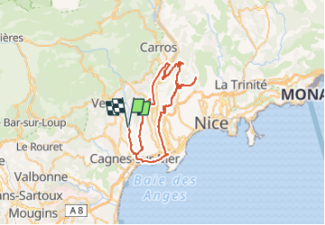
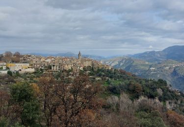
Trail Road bike of 64 km to be discovered at Provence-Alpes-Côte d'Azur, Maritime Alps, Cagnes-sur-Mer. This trail is proposed by bosses21.
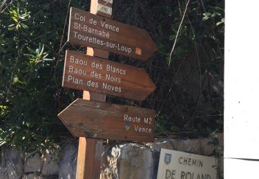
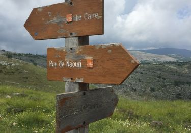
Description

Le Collet - 311 m /
La Baisse - 308 m /
Col de Bast - 291 m /
Collet du Pioum - 315 m

Elevation profile

Points of interest

Point of interest Colomars - Le Collet - Photo
bosses21
COLOMARS 
Point of interest Colomars - La Baisse - Photo
bosses21
COLOMARS 
Point of interest Nice - Col de Bast - Photo
bosses21
Point of interest Nice - Collet du Pioum - Photo
bosses21

Positioning

Country:
France
Region :
Provence-Alpes-Côte d'Azur
Department/Province :
Maritime Alps
Municipality :
Cagnes-sur-Mer
Location:
Unknown
Start:(UTM)
350349 ; 4839752 (32T) N.

Trails nearby

Trail Walking La Gaude - La Gaude - Bord de Cagnes - Photo
Walking
triburemy

Walking

Very difficult
La Gaude, Provence-Alpes-Côte d'Azur, Maritime Alps, France
7.7 km | 11.4 km-effort
3h 19min
Yes
Trail Walking La Colle-sur-Loup - La colle sur Loup/Tourette  - Photo
Walking
GrouGary

Walking

Easy
La Colle-sur-Loup, Provence-Alpes-Côte d'Azur, Maritime Alps, France
15.3 km | 23 km-effort
4h 38min
Yes
Trail Walking Villeneuve-Loubet - Parc departemental des Rives du Loup. - Photo
Walking
Dervalmarc

Walking

Very easy
Villeneuve-Loubet, Provence-Alpes-Côte d'Azur, Maritime Alps, France
6.9 km | 8 km-effort
1h 23min
Yes
Trail Walking Vence - Vence Baou des noirs et des blancs  - Photo
Walking
pjjrevrard

Walking

Very easy
Vence, Provence-Alpes-Côte d'Azur, Maritime Alps, France
8.9 km | 14.1 km-effort
3h 22min
Yes
Trail Walking Vence - Balade ch de Sine Vence avec Guillaume - Photo
Walking
GrouGary

Walking

Very easy
Vence, Provence-Alpes-Côte d'Azur, Maritime Alps, France
9.5 km | 11.8 km-effort
4h 14min
Yes
Trail Walking Vence - Mal an effectué  - Photo
Walking
Renefrt

Walking

Medium
Vence, Provence-Alpes-Côte d'Azur, Maritime Alps, France
8.8 km | 13 km-effort
5h 43min
Yes
Trail Walking Vence - Balisage GR653A 16-12-2023 - Photo
Walking
MoGi06

Walking

Easy
Vence, Provence-Alpes-Côte d'Azur, Maritime Alps, France
4.3 km | 5.9 km-effort
5h 30min
No
Trail Walking Vence - Naouri avec problème de réception  - Photo
Walking
Renefrt

Walking

Medium
Vence, Provence-Alpes-Côte d'Azur, Maritime Alps, France
10.1 km | 18.1 km-effort
5h 54min
Yes
Trail Road bike La Gaude - la gaude-le broc - Photo
Road bike
triburemy

Road bike

Difficult
La Gaude, Provence-Alpes-Côte d'Azur, Maritime Alps, France
44 km | 52 km-effort
2h 12min
Yes


Close
My subscriptions