


Oberbruck - Gazon vert

Alain28/01
User
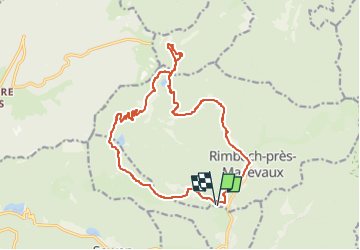

Length
17.2 km

Max alt
1147 m

Uphill gradient
819 m
Km-Effort
28 km

Min alt
534 m

Downhill gradient
818 m
Boucle
Yes
Creation date :
2022-07-19 10:18:47.574
Updated on :
2022-07-19 10:20:37.612
6h23
Difficulty : Very difficult

FREE GPS app for hiking
 SityTrail
IGN / Geographical institutes
SityTrail Plus
The world is yours!
About
Trail Walking of 17.2 km to be discovered at Grand Est, Haut-Rhin, Rimbach-près-Masevaux. This trail is proposed by Alain28/01.
Positioning
Country:
France
Region :
Grand Est
Department/Province :
Haut-Rhin
Municipality :
Rimbach-près-Masevaux
Location:
Unknown
Start:(Dec)
Start:(UTM)
345811 ; 5298155 (32T) N.
Comments