2022-07-23_10h13m57_9eich

rolandwin
User

Length
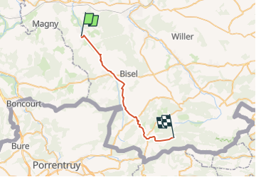
26 km

Max alt
791 m

Uphill gradient
674 m
Km-Effort
33 km

Min alt
329 m

Downhill gradient
270 m
Boucle
No
Creation date :
2022-07-23 08:13:57.777
Updated on :
2022-07-23 08:14:11.745

FREE GPS app for hiking
 SityTrail
IGN / Geographical institutes
SityTrail Plus
The world is yours!
About
Trail of 26 km to be discovered at Grand Est, Haut-Rhin, Strueth. This trail is proposed by rolandwin.
Positioning
Country:
France
Region :
Grand Est
Department/Province :
Haut-Rhin
Municipality :
Strueth
Location:
Unknown
Start:(Dec)
Start:(UTM)
358925 ; 5272138 (32T) N.
Comments