


casiers de brandis

amlubac
User
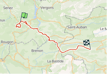

Length
50 km

Max alt
1558 m

Uphill gradient
1297 m
Km-Effort
67 km

Min alt
722 m

Downhill gradient
1252 m
Boucle
No
Creation date :
2022-07-27 07:43:36.907
Updated on :
2022-07-27 14:59:13.878
6h08
Difficulty : Very difficult

FREE GPS app for hiking
 SityTrail
IGN / Geographical institutes
SityTrail Plus
The world is yours!
About
Trail Walking of 50 km to be discovered at Provence-Alpes-Côte d'Azur, Alpes-de-Haute-Provence, Castellane. This trail is proposed by amlubac.
Positioning
Country:
France
Region :
Provence-Alpes-Côte d'Azur
Department/Province :
Alpes-de-Haute-Provence
Municipality :
Castellane
Location:
Unknown
Start:(Dec)
Start:(UTM)
296236 ; 4860105 (32T) N.
Comments