


Aubazines : Canal des Moines TC

mitch1952
User
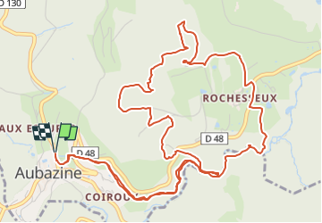

Length
8.8 km

Max alt
516 m

Uphill gradient
268 m
Km-Effort
12.4 km

Min alt
298 m

Downhill gradient
268 m
Boucle
Yes
Creation date :
2022-08-01 17:00:01.542
Updated on :
2022-08-01 17:01:40.062
2h48
Difficulty : Easy

FREE GPS app for hiking
 SityTrail
IGN / Geographical institutes
SityTrail Plus
The world is yours!
About
Trail On foot of 8.8 km to be discovered at New Aquitaine, Corrèze, Aubazines. This trail is proposed by mitch1952.
Positioning
Country:
France
Region :
New Aquitaine
Department/Province :
Corrèze
Municipality :
Aubazines
Location:
Unknown
Start:(Dec)
Start:(UTM)
395554 ; 5003330 (31T) N.
Comments