


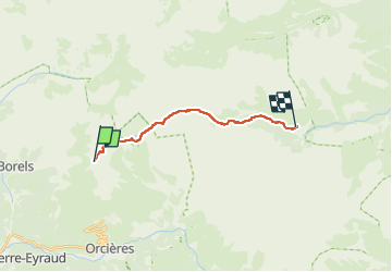
SOMMET DU DROUET - LAC DES ESTARIS - DORMILLOUSSE - 13km

jpb83
User

Length
13.4 km

Max alt
2782 m

Uphill gradient
386 m
Km-Effort
21 km

Min alt
1680 m

Downhill gradient
1242 m
Boucle
No
Creation date :
2022-08-02 09:05:23.263
Updated on :
2022-08-02 09:05:26.09
4h52
Difficulty : Medium

FREE GPS app for hiking
 SityTrail
IGN / Geographical institutes
SityTrail Plus
The world is yours!
About
Trail Walking of 13.4 km to be discovered at Provence-Alpes-Côte d'Azur, Hautes-Alpes, Champoléon. This trail is proposed by jpb83.
Positioning
Country:
France
Region :
Provence-Alpes-Côte d'Azur
Department/Province :
Hautes-Alpes
Municipality :
Champoléon
Location:
Unknown
Start:(Dec)
Start:(UTM)
287545 ; 4955576 (32T) N.
Comments