


Camp 2022 - mont rond d’en bas

norbertmarteau
User
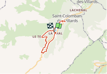

Length
13 km

Max alt
1526 m

Uphill gradient
595 m
Km-Effort
21 km

Min alt
1100 m

Downhill gradient
595 m
Boucle
Yes
Creation date :
2022-08-02 11:49:31.0
Updated on :
2022-08-02 17:40:33.096
5h47
Difficulty : Very difficult

FREE GPS app for hiking
 SityTrail
IGN / Geographical institutes
SityTrail Plus
The world is yours!
About
Trail Walking of 13 km to be discovered at Auvergne-Rhône-Alpes, Savoy, Saint-Colomban-des-Villards. This trail is proposed by norbertmarteau.
Positioning
Country:
France
Region :
Auvergne-Rhône-Alpes
Department/Province :
Savoy
Municipality :
Saint-Colomban-des-Villards
Location:
Unknown
Start:(Dec)
Start:(UTM)
281258 ; 5018092 (32T) N.
Comments