Trail Walking Fos - 2022 TRANSPYRÉNÉEN 2 - FOS - le REFUGE de l’étang d’ARAING - Photo

2022 TRANSPYRÉNÉEN 2 - FOS - le REFUGE de l’étang d’ARAING

 LEGUE
LEGUE

User

© OpenStreetMap contributors
Length
Length
17.5 km
Max alt
Max alt
2200 m
Uphill gradient
Uphill gradient
1722 m
Km-Effort
Km-Effort  
36 km
Min alt
Min alt
552 m
Downhill gradient
Downhill gradient
340 m
Boucle
Boucle
No
Creation date :
2022-08-03 06:05:12.0
Updated on :
2022-08-04 05:05:46.342

(0 Reviews)

Walking
Walking
5h31
Difficulty : Very difficult

Scan this QR Code to open this trail in the SityTrail application

FREE GPS app for hiking

Logo SityTrail SityTrail

IGN / Geographical institutes

Download SityTrail from the App Store Download SityTrail from Google Play

Logo SityTrail SityTrail World

The world is yours!

Download SityTrail from the App Store Download SityTrail from Google Play Download SityTrail on Huawei AppGallery

About

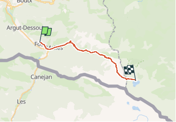
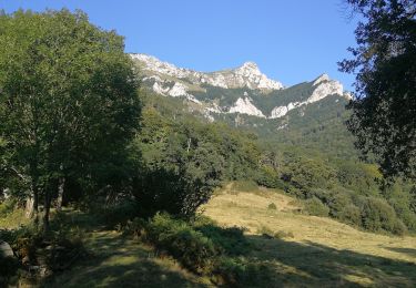
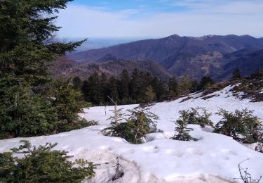
Trail Walking of 17.5 km to be discovered at Occitania, Haute-Garonne, Fos. This trail is proposed by LEGUE.

Description

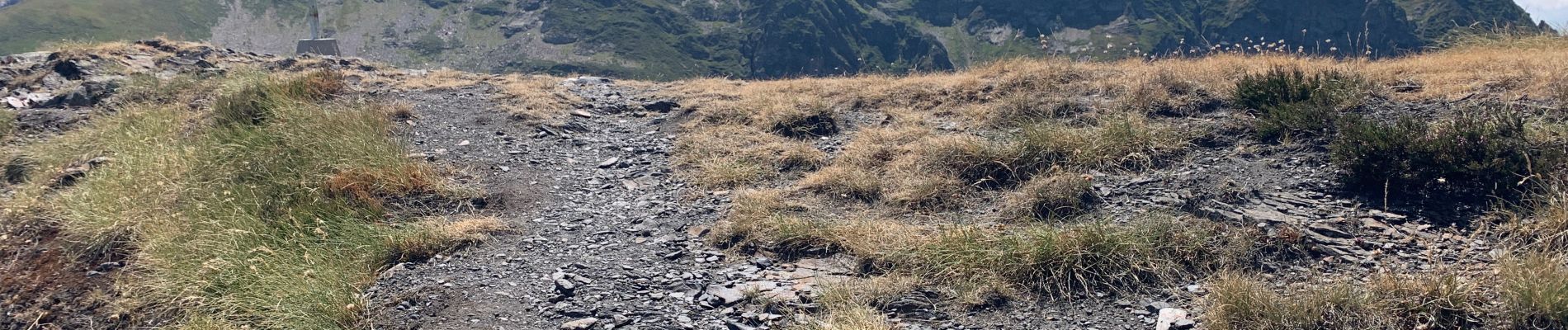
Encore une journée    environ 1800m de dénivelés positif
Et 200m négatif
Paysages superbes !

Elevation profile

Photos

Positioning

Country:
France
Region :
Occitania
Department/Province :
Haute-Garonne
Municipality :
Fos
Location:
Unknown
Start:(UTM)
315290 ; 4749314 (31T) N.

Trails nearby

Trail On foot Bausen - Fageda de Carlac - Photo
On foot
PRO

On foot

Easy
Bausen, Catalonia, Lleida, Spain
6.2 km | 10.8 km-effort
2h 27min
Yes
Trail Walking Fos - Cap des Hittes en boucle - Photo
Walking
chrisgps

Walking

Difficult
Fos, Occitania, Haute-Garonne, France
13.3 km | 32 km-effort
7h 25min
Yes
Trail Walking Boutx - Tuc de l'Etang et Pic d'Escales - Photo
Walking
tracegps

Walking

Difficult
Boutx, Occitania, Haute-Garonne, France
5.8 km | 11.3 km-effort
2h 55min
Yes
Trail Walking Bausen -  Cabana de Serralonga depuis Bausen - Photo
Walking
chrisgps

Walking

Medium
Bausen, Catalonia, Lleida, Spain
11.4 km | 22 km-effort
5h 4min
Yes
Trail Walking Boutx - SityTrail - GR86new - Photo
Walking
zazibelle

Walking

Very difficult
Boutx, Occitania, Haute-Garonne, France
9.1 km | 16.4 km-effort
70h 32min
No
Trail Snowshoes Boutx - 2021-02-16  raquettes le mourtis - Photo
Snowshoes
jacq58

Snowshoes

Easy
Boutx, Occitania, Haute-Garonne, France
3.5 km | 7.9 km-effort
10min
Yes
Trail Snowshoes Boutx - 03-01-2021 Mourtis tuc de l’étang  - Photo
Snowshoes
jacq58

Snowshoes

Easy
Boutx, Occitania, Haute-Garonne, France
3.9 km | 7.2 km-effort
1h 21min
Yes
Trail Walking Boutx - mourtis puc de l'etang - Photo
Walking
ellahove

Walking

Easy
Boutx, Occitania, Haute-Garonne, France
6.1 km | 10.8 km-effort
2h 6min
Yes
Trail Walking Boutx - Tuc de l'Etang en boucle - Photo
Walking
chrisgps

Walking

Medium
Boutx, Occitania, Haute-Garonne, France
14.7 km | 28 km-effort
5h 48min
Yes


Close
My subscriptions