


Trace Miel Bernard

mitch1952
User
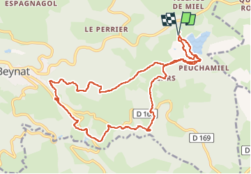

Length
11.7 km

Max alt
523 m

Uphill gradient
280 m
Km-Effort
15.4 km

Min alt
385 m

Downhill gradient
282 m
Boucle
Yes
Creation date :
2022-08-04 06:21:54.0
Updated on :
2022-08-04 09:31:09.827
3h07
Difficulty : Unknown

FREE GPS app for hiking
 SityTrail
IGN / Geographical institutes
SityTrail Plus
The world is yours!
About
Trail Walking of 11.7 km to be discovered at New Aquitaine, Corrèze, Beynat. This trail is proposed by mitch1952.
Positioning
Country:
France
Region :
New Aquitaine
Department/Province :
Corrèze
Municipality :
Beynat
Location:
Unknown
Start:(Dec)
Start:(UTM)
402721 ; 4998264 (31T) N.
Comments