


SityTrail - Boucle de Limeuil

pidjam
User
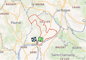

Length
13.5 km

Max alt
207 m

Uphill gradient
212 m
Km-Effort
16.3 km

Min alt
49 m

Downhill gradient
209 m
Boucle
Yes
Creation date :
2022-08-09 07:51:03.38
Updated on :
2022-08-09 08:04:30.785
3h42
Difficulty : Difficult

FREE GPS app for hiking
 SityTrail
IGN / Geographical institutes
SityTrail Plus
The world is yours!
About
Trail Walking of 13.5 km to be discovered at New Aquitaine, Dordogne, Limeuil. This trail is proposed by pidjam.
Description
Au confluent de la Dordogne et de la Vézère, la jolie petite ville de Limeuil et ses jardins panoramiques.
Positioning
Country:
France
Region :
New Aquitaine
Department/Province :
Dordogne
Municipality :
Limeuil
Location:
Unknown
Start:(Dec)
Start:(UTM)
333362 ; 4972095 (31T) N.
Comments