


Trace Puy de Noix

mitch1952
User
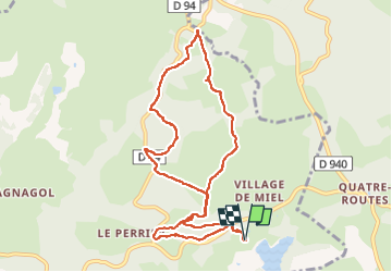

Length
10.3 km

Max alt
565 m

Uphill gradient
245 m
Km-Effort
13.5 km

Min alt
462 m

Downhill gradient
242 m
Boucle
Yes
Creation date :
2022-08-11 06:16:19.0
Updated on :
2022-08-11 08:51:09.818
2h33
Difficulty : Unknown

FREE GPS app for hiking
 SityTrail
IGN / Geographical institutes
SityTrail Plus
The world is yours!
About
Trail Walking of 10.3 km to be discovered at New Aquitaine, Corrèze, Beynat. This trail is proposed by mitch1952.
Positioning
Country:
France
Region :
New Aquitaine
Department/Province :
Corrèze
Municipality :
Beynat
Location:
Unknown
Start:(Dec)
Start:(UTM)
402735 ; 4998278 (31T) N.
Comments